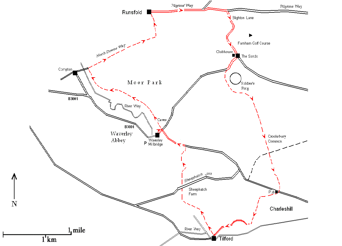
A routine walk in the Godalming area was used as a test case to see whether a randomly selected piece of the Surrey commuter-belt would turn out to reveal an underlying megalithic imprint. The experiment proved notably successful so, while on this walk, you can be mentally preparing to convert over-familiar Sunday afternoon jaunts into much more revealing strolls down megalithic memory lane. Choosing as a starting-point Waverley Abbey, the first Cistercian house in England, might come across as something of a cheat but at the time, in the days of our Megalithic innocence, it just seemed the kind of local place of interest that any self-respecting walk leader would use.
Waverley abbey was built near the crossing point of two important routes, the east-west ‘Pilgrims Way’ and the north-south Portsmouth to London road, now the A3. Was it mere coincidence that an unworldly bunch of religious (the Cistercians were a famously austere reform branch of the Benedictine order) should select such a strategic site for their enterprise? When you are out walking it is always worth considering how and when Continental influences integrated into the unfolding but unchanging warp-and-woof of the British countryside. And vice versa of course.
The Cistercian movement arrived in Britain during the twelfth century and was still around four hundred years later when Henry VIII brought Merrie England to an end. Alternatively, the Cistercians can be viewed through the other end of the telescope as the precursors of the modernising Tudors because they introduced modern capitalistic methods to the somewhat somnolent post-Domesday agrarian society. But there is a third way to view the Cistercians, as a late flowering of a much more ancient tradition. Their most famous abbot, Bernard of Clairvaux (the location of his foundation was in the Vallée d’Absinthe) helped draft the founding charter of the Knights Templar in 1128, the year that Waverley Abbey was founded. As we know by now, the Knights Templar are just the Megalithics in a modern guise.

Route: Waverley Abbey – Pilgrim’s Way – Soldier’s Ring – Crooksbury Common – Tilford – Waverley Abbey
Length: 8 miles
You will need OS Explorer 145 or OS Landranger 186.
Coming by car, from the A31 take the B3001 Farnham to Godalming road (look for a junction with a set of traffic lights and a large pub/hotel called Mekki’s, formerly The Exchange, on the corner). The road at first is called Station Hill; go straight ahead over the mini-roundabout where the road name changes to Waverley Lane. Waverley House and Abbey are signposted on the right just before the road bends sharply to the left at Waverley Mill Bridge (grid ref. SU870455). There is a free car park with limited spaces just off the road almost opposite the weir. Before leaving the car park, go through the kissing gate for a view of the ruined abbey buildings in an idyllic setting beside the river Wey, with a hump-backed stone bridge in the background. There is little left of the structure since, after the Dissolution, much of the stone was removed and used to build Loseley House, of yoghurt fame.
Turn right out of the car park and walk a short distance along the B3001 to Waverley Mill Bridge passing the weir. Weirs are often to be found next to fords and bridges. Although prehistoric fishing artefacts themselves have not survived, fish-ponds, weirs and lagoons were exploited in every era, so that mini-industrial complexes grew up at these strategic points. The crossroads is a natural market for the fish but in this case, and characteristically, it would be the sheer number of monks that needed feeding. In the records, monasteries are always to be found vociferously arguing their case against other riparian interests.
Notice how sharply the road bends to the left to accommodate the mill and then bends just as sharply to the right at the crossroads. Often the original reason for these sudden deviations will be long gone, but the deviation itself tells you that something used to be here. Conversely, keep an eye out for straight tracks, some now country roads, which constantly shepherd you along the regular routes the Cistercian flocks followed. As you walk you should also note any narrow entrances and exits as potential toll-points, especially where there is only one possible route, for example where the river is close to the path.
The mill race which passes underneath the road can be viewed on either side. Mill races are always evidence of industrial activity, not generally just an individual flour-mill (hardly worth the expense of a race) but some kind of integrated activity on a larger scale. Ahead is a minor road, Camp Hill. This is your introduction to the military life which abounds in this area. Whether this “camp” is Roman, Iron Age or Bronze Age (or all three) awaits your investigation. Never assume it wasn’t built by squaddies in the Second World War, this whole area being littered with military detritus through the ages. Turn left where the road bends right and follow the signed footpath past a house called Stella Lodge squarely at the point where the tracks cross. Here the path is narrow and straight for a short stretch until you reach a gate. This is highly indicative of a toll point, next to a bridge over the river with an adjacent mill. Normally Stella Lodge would be the toll-keeper’s cottage, except that the name suggests later and grander aspirations. Beyond the gate a notice tells you this is Moor Park nature reserve. On the left of the path is the river and on the right looms a steep continuous embankment; there is no choice but to keep to the straight and narrow.
A few yards from the mill, on the right, you reach Mother Ludlam’s Cave. It used to be called Luddwelle or Ludewell, named after the British god of healing, Lud or Llud[1], and provided the White Monks with a clean water supply. On the left of the path is an alder swamp or alder carr, carr meaning a type of woodland with peaty soil. According to another nature reserve notice, kingfishers and herons abound here so clearly plenty of fish still remain. After the atmospheric alder swamps (and creepy, in a mist-enveloped Morte d’Arthur kind of way) the view on the left opens out to the grassy fields of the Wey water meadows.

Entrance to Mother Ludlam’s Cave
The interior is inaccessible behind fancy grille-work but the spring to which the cave owes its importance can be seen trickling down from the entrance. Access from the path to the river Wey is obstructed by the alder swamp. Possibly deliberately to enhance Mother Ludlam’s earning capacity.
The path continues north past the elegant façade of Moor Park House and comes to a cross-roads where it joins the North Downs Way, a modern long distance trail going west-east from Farnham to Dover, set up in 1978. Moor Park House, on the site of the earlier Compton Hall,[2] was renamed by William Temple, a fomenter of the Glorious Revolution. One visitor to Moor Park was Jonathan Swift who befriended a “Stella” thought to be a serving-maid in the household and presumably connected with Stella Lodge [but be wary of such over-careful explanations which have a tendency to become ‘fact’ ]. Sir William’s heart is, bizarrely, buried in the garden in a silver box under the sundial. The name Temple, a heart, a silver box and a sundial will provide enough material for the outline of a successful Gothic novel by the time you finish your walk.
At the road junction you will see a fingerpost pointing right and left to the North Downs Way. If you continued straight ahead at the crossroads on the footpath it would lead you to the Shepherd and Flock roundabout on the A31. Turn left and walk up the road a few yards till you come to another fingerpost on the left. Follow the path which now levels out and goes across open country with a hedge on the left. It leads through Runfold Wood. Notice the layered hedge bordering the path on the left; this ancient technique of encouraging new growth by pegging down shoots so they take root is called plashing. The mixture contains underwood and timber trees with a preponderance of beeches. This type of woodland looks natural but is in fact carefully managed; the underwood, the most important part, supplies local needs uninterruptedly as long as the trees are coppiced, i.e. cut down to stumps, on a regular basis. Trees grown for timber can live for hundreds of years but are usually harvested before they are fully mature, very large trunks being hard both to transport and to fashion. Keep straight along the path until you reach a T-junction where you turn left. The track will probably be muddy as it is used by motorbike riders. On the right is another example of woodland management, a spinney of trees planted closely so they have grown tall and straight as poles.
At the end of the path turn right and walk along the road for a short distance towards Runfold. There is a path on the left-hand verge and after passing a cordoned-off extraction pit you will see a grassy triangle with a footpath sign pointing left which leads directly north to the Pilgrims’ Way within a few minutes’ walk. The path is straight and restricted, only wide enough for people or animals to travel singly or at most two abreast. The first building on the left at the junction with the Pilgrims’ Way, The Princess Royal Lodge, is now the only pub in the village but was presumably rather more important in earlier times. Opposite the pub are stables and it is likely they were all once the same establishment. This section of the Pilgrims’ Way is tarmaced over, part of a road (the old A31) built on the south-facing escarpment eschewing the top of the ridge; it goes parallel to the present A31 Farnham to Guildford bypass on the exposed Hog’s Back over to your left. You are not required to do any real road-walking as a path separated by a narrow grass verge runs alongside and there is not a great deal of traffic, most of which is on the present A31.
A quarter of a mile on you come to a fork where you bear right along a minor road signposted to Seale and then turn right after a few yards down Blighton Lane. In a quarter of a mile you will see a fingerpost on the left where the North Downs Way joins the lane. Much of the North Downs Way comprises woodland tracks; if you follow it a little way into the woods on either side of the road you will see earth banks running alongside which are noticeably straight and definitely not natural. This suggests the trail, even though recent, is keeping to the earlier Megalithic route because these banks are there to ensure travellers kept to the track.
The lane comes to a T-junction with Farnham golf course on the left. The golf clubhouse on the right was clearly also once an inn and behind it there is a converted stableyard. Turn left and follow the road towards The Sands for a few yards, then turn right down Botany Hill. Archaeologists have identified “a defensive enclosure” further down the hill that they classify as contemporaneous with, and almost identical to, the Soldier’s Ring—if true, a perplexing example of building the same thing twice. It is hard to tell what is going on here since everywhere seems to have been commandeered by private estates but building big houses on local eminences and keeping the hoi polloi out is evidently an established British tradition, carried on in the Surrey Hills by the musical idols of our youth whom we would have spurned instantly had we known they were country landowners manqués.
Just past a lane on the left and immediately before a Neighbourhood Watch notice you come to a public bridleway sign on the left. Almost immediately in front of you is an enormous mound which is marked ‘Soldier’s Ring (earthwork)’ on the OS map. The Soldier’s Ring, one of several prehistoric earthworks on Crooksbury Common, is just north of Crooksbury Hill, the highest point.

Soldier’s Ring earthwork
Notice how dense the pine trees are, suggesting a well-tended plantation. Pine-tar producing trees are immensely important to Megalithic enterprises; indeed a vast swathe of the Atlantic coast in western France, known as Les Landes and the heartland of Megalithic trade and industry, is devoted to pine trees.
Where the path forks, keep to the main right-hand track through the wood indicated by posts painted pale blue. When the path reaches a road, Smugglers’ Way (!), cross over and keep to a straight track, Crooksbury Lane, past houses with Stone Hill on the right, until it ends at Long Hill where you turn right. A noticeboard informs you that this is Crooksbury Common. It is a good example of the type of undulating open heathland which becomes increasingly familiar the further you progress into England’s southern ‘badlands’ stretching all the way from the London clays to the other side of the New Forest in Dorset. On the map you can see a couple of tumuli marked, one of which is visible under the heather only because the trees have been cut down, which makes you wonder which of the hilly bits here are natural and which are man-made.
The bridleway is half a mile long; it leaves the heath and continues south as a woodland track for another half mile with a few partially screened houses on both sides until it reaches the B3001 at Charles Hill near the river. Cross the road and immediately opposite is a footpath which leads you past The Donkey pub, strategically situated at this junction of east-west and north-south routes. At some stage the path has been diverted from its original course. The Donkey used to be The Half-Way House, presumably because this is the half-way point between Farnham and Milford, a strategic point on a well-used, former prehistoric track.[4]
Keep straight along the tarmaced path for a short distance past a row of houses on the left until it bears left and becomes a muddy woodland path which soon goes downhill. After about half mile you come to Whitmead House on the left where the path bends sharp right to join a minor road, Whitmead Lane, and, still going downhill, leads to Tilford. To the left of the lane you look over the River Wey and more water-meadows. Where the lane divides take the left-hand fork and continue downhill to a T-junction where you turn left onto the road into Tilford. Notice the straight row of pollarded trees beside the village street on the approach to the bridge. For those interested in trees it is worth going over the bridge and on to the village green to see the King’s Oak which is thought to be eight hundred years old; it appears on old maps as ‘Novel’s Oak’, most likely a form of newel (which came to mean a central stair column and then a post at the top or bottom of a staircase). The oak is mentioned in the ‘perambulation of Waverley Abbey’ as one of the estate’s boundary markers; the landowner, the Bishop of Winchester, reportedly once tried to fell it, perhaps as part of a land-grab, but was stopped by an angry village mob. Perambulations, or ‘beating the bounds’, which were usually carried out every seven or ten years, involved the whole community; they were necessary to reaffirm estate boundaries as well as settle wider parish issues, such as exemptions from forest law. This folk tale about the bishop is interesting because, generally speaking, with literacy, written records meant it was no longer necessary to mark boundaries by ceremony but it should not be forgotten that “the written record” was in the keeping of the clergy so it makes a lot of sense when the clergy are your neighbours to keep the old ways going a little longer.
Follow the road for a few yards until the bend where it crosses the Wey; just before the bridge, turn right onto a signed bridleway which heads back to Waverley Abbey. The bridleway is very narrow to start with which suggests it was a toll passage. Certainly any horses would be forced to go in singe file at this point. With the river on the left and a steep bank on the right, users have no alternative but to keep to the path, similar to the track crossing Moor Park nature reserve.
Continue along a short stretch of tarred road with houses on the right till you reach a fork where you take the right-hand path, marked Greensand Way on the map, until it reaches a minor road. The road is Sheephatch Lane with Sheephatch Farm at the junction; once you have crossed the road the path widens and becomes suitable for drovers and their flocks. A hatch is another word for gate indicating that the lane may have been a sheep-drive where animals could be penned and counted before crossing the river. To the west of Sheephatch Farm the lane leads to nearby Tilford Mill Bridge, where a fulling mill for the woollen industry was in use in the fourteenth century, at the height of Cistercian influence. Keep along the track until it meets the road where you turn left and walk a few yards down to Waverley mill. Ahead of you is Stella Lodge at the corner of the through-route to the Pilgrims’ Way. Turn left and follow the bend of the road over the mill race and so back to Waverley Abbey car park.
[1] Lud , Llud or Lugh was a ‘triple-headed’ god, appropriated by the Romans as Mercury, who later became Christianised as the Archangel Michael. They are of course all versions of Hermes so Lud place-names are always of Megalithic significance.
[2] Compton is a hamlet on the Pilgrims’ Way just south of the Hog’s Back and Loseley House. Its distinguishing feature is the two-storey church, the only one of its kind in Britain.
[3] The same situation occurs at Halfway Village which is midway between Hungerford and Newbury on the A4, another major east-west route. In the same vein, Middleton is one of the commonest place-names in the British Isles. Midhurst, halfway between Farnham and Portsmouth, has a church dedicated to St. Mary Magdalene (q.v.) and St. Denys (q.v.) which stood on the summit of Tan Hill (q.v.), the site of Midhurst’s Norman castle (q.v.), and over the road is Rumbold’s (q.v.) Hill where the town Mint is located, making Midhurst one of the half dozen most important towns in the land.
[1] Lud , Llud or Lugh was a ‘triple-headed’ god, appropriated by the Romans as Mercury, who later became Christianised as the Archangel Michael. They are of course all versions of Hermes so Lud place-names are always of Megalithic significance.
Leave a Reply