Since it became a National Park in 1951 Dartmoor has been popular with walkers and pony-trekkers but, in practice, you can walk all day without seeing another human being. As you pick your way across tussocks of grass and apparently random boulders, it is easy to imagine the landscape has remained more or less unchanged except perhaps for the television mast above Princetown. But in fact the Big Question to ask yourself during this walk is ‘What’s Dartmoor really all about?’ Clearly it’s a blasted heath so the question might be ‘Who Blasted The Heath?’ And it wasn’t the Army even though there are live firing ranges.
To answer these kinds of questions you should be on the lookout for oddities. One thing you will notice on the moor are the rows of stones for which nobody has an explanation. Similarly inexplicable are the ‘wild’ Dartmoor ponies that will practically eat your lunch if you’re not careful. If you put these two anomalies together you immediately have your explanation: Dartmoor is where they mined most of the megalithic stones which were arranged in rows ready to be transported across Megalithic Britain by the Dartmoor ponies. When the system came to an end the stones that had been mined but not removed were left in their forlorn rows. The ponies were left to go feral.
Assessing distances when scrambling around tors is always difficult—allow for a walking speed of not more than two miles an hour. Avoid wearing shorts in the summer as horseflies and ticks can be a nuisance (special tweezers exist for removing them from man and dog). A compass is essential on Dartmoor since the weather can close in without warning and you cannot rely on finding marked paths; even if you do fix on a landmark it may not remain in view. You will need to set a course in a certain direction and check your compass at intervals. It is a good idea to note the schedule of firing (ranges are marked ‘Danger Area’ in red on the OS map); if a red flag is flying by day, or a red lamp at night, it means live firing is taking place. The ranges are marked by red and white posts and in some places fenced off.

Route: Merrivale – Roos Tor – Langstone Moor – White Tor – Merrivale
Length: 8 miles
You will need OS Explorer 028 or Landranger 191.
To drive to Merrivale, situated on the western side of Dartmoor about five miles east of Tavistock, take the B3357 from Tavistock signposted to Princetown. The B3357, which bisects Dartmoor in an east-west line, was a medieval packhorse trail and has even earlier roots as a prehistoric track. Pass over the cattle grid marking the beginning of the moor and a 40 mph speed limit and continue along the road to the fourth car park on the right at the eastern end of Merrivale. The car park backs onto Merrivale and is bordered by a clump of trees enclosed by a low stone wall. Once you start climbing up onto the moor you no longer see the clump but it is a useful marker when looking for the otherwise indistinguishable car park.

Merrivale. Looking north from the ‘blocking stone’ at the eastern end of the northerly double stone row.
The clump of trees marks the edge of the car park at Merrivale, perhaps originally planted as a roadside marker or a windbreak. The car park is sometimes called ‘Four Winds’.
Beyond the trees there is a leat or stream running beside the stone wall[1] which makes the ground boggy but there are plenty of stepping stones. As you approach the stone rows the ground gets drier which is unlike the bogs and general wetness for which Dartmoor is notorious. The leat running through the middle of the megalithic rows is strictly a nineteenth-century construct.

Plan of Merrivale
The drawing shows the two double rows of stones which are completely straight though the southern row is not quite parallel to the northern row. The stone circle almost half-way along the southern row contains a small cairn. Near the western end of the southern row is another small cairn from which a single stone row heads off south-west. It has been suggested that the rows point to where the Pleiades (the Seven Sisters) rise at the time of the May sunrise. This is the kind of special pleading that brings alignment theory into disrepute. If you can choose the astronomical landmark and the month, it is not difficult to line up anything with something.
Before setting off on the walk, examine Merrivale closely. You will find two double stone rows about a quarter of a mile long lying more or less parallel next to the road, and beyond them more stones in what may be some kind of organisation—rows, enclosures, circles, cairns and so forth—the whole resembling the ordered confusion of a department store. It is the quantity of stones that is so striking, reminiscent of the French collection at Carnac although Merrivale is on a less grandiose scale. There are two possible interpretations: either this jumble is a ritual assemblage, as archaeologists tend to assume, or they are industrial scrag ends. Consider, for instance, how close you are to the quarry and how level the site is compared to the surrounding terrain. Has it been specially levelled and, if so, for ritual purposes or to allow a pony and loading-sledge easy access? The car park you used is right on the edge of the road immediately next to the stones, which is surely a prime position for a loading bay. No doubt the ground got churned up in the process leading to the name Merrivale, ‘miry vale’. Don’t forget to examine the various trackways that come to and from this industrial depot. Or outdoor ritual site of course.
From Merrivale walk a short distance westwards along the grass verge of the road to a white cottage a few yards on from the Dartmoor Inn, marked PH on the map. To the east is the spire of the TV mast high above Princetown which can be seen for miles, a very useful landmark to guide you on the way back. Just beyond the cottage is Merrivale quarry, a cliff of granite towering above the road. Dartmoor seems remote to our Metropolitan lowland sensibilities but actually it is accessible from both the Bristol and English Channels, and handy for Wessex. It is expensive toting granite around in any era but if you are putting up marker stones for the long haul (and Megalithia lasted several thousand years) it pays you to use hardwearing Dartmoor granite rather than softer local stone[2]. It is worth keeping all this in mind as you look at Merrivale through ‘megalithic’ eyes and find an answer to the conundrum: what were all those stones for?
On the right of the road you will see a cinder track leading up towards the quarry through an open gate. Follow the track past some disused quarry sheds towards the granite cliff, peering down at an ominous-looking pool as you go. To the right of the cliff you will see a bridge spanning the leat and a path that heads uphill northwards away from the quarry. A leat is an artificial watercourse diverted from a river or stream, in this instance the River Walkham, that carries water to a mill or an industrial site. Notice the straightness of the leat and how it runs down to the head of Merrivale quarry. Straightness is important for increasing flow which in turn powers machinery, both ancient and modern.
The path veers slightly north-west between the three Staple tors forming a conspicuous ridge on the right and Cox Tor ahead on the left. On the summit of Great Staple Tor notice the fantastically shaped rocks which seem to be about to topple over at any moment and ask yourself if they are the result of ‘weathering’ or are in fact a man-made feature. To the north of Staples Tors is Roos Tor, looking as if a giant mushroom has been plonked on its summit. As you walk, keep thinking about this remarkable feature looming on the skyline because it represents a parting of the ways. Geologists say this is natural. Just possibly it may be if it were the only one, but there are so many of these formations the Cornish actually have a name for them, logan stones, log meaning ‘to rock’ or ‘roll’ in local dialect. If you meet an archaeologist or a geologist on your walk ask them how come we live at such a magical moment in geological time when all these constantly weathering rocks are vertiginously balanced for our delectation.

Roos Tor (looking south-west towards Merrivale)
‘Roos’ means marsh or moorland. The tor is halfway between the B3357 at Merrivale and the Lich Way. The tilted outline of this ’logan stone’ is a distinctive landmark on the skyline. One of the best of the logan stones is The Cheesewring on Bodmin Moor which is on the Michael Line. Granite can be weathered into fantastic shapes so there is understandable uncertainty as to whether logan stones are natural or man-made but logan stones are integral to the system of connected visual aids, the sighting of Brent Tor from Roos Tor being a good example.
While marvelling at how this boulder came to be positioned so precisely, you will also be able to make out a distinctive cone-shaped hill with a spire on top, six or seven miles away to the north-west. It will instantly remind you of Glastonbury Tor, which is probably no coincidence because you are looking at Brentor, and the spire on the pinnacle belongs to St Michael’s Church. Brentor is on the Michael Line, which also passes Glastonbury Tor.

Brentor
The cone shape of Brentor with its distinctive church tower is visible from miles away and is of particular interest as it is sited on the Michael Line. It is clearly intended to be a landmark rather than a place of worship. At any rate pastors of St. Michael’s used to complain about the uphill trudge, as no doubt did their parishioners. Brentor St. Michael’s is an example of one of the inherent inconveniences of the Megalithic System: on the one hand it is highly visible to travellers from all directions, but on the other nobody wants to walk right up to the summit in order to make the next sighting. Signposts do the job much better but they have to await literacy.
Situated on the western edge of the moor at its widest point, equidistant between Tavistock and Lydford, Brentor can be seen from Plymouth Sound. The hill is a landmark on an ancient coast-to-coast route from the English Channel to the Bristol Channel much used by traders for whom crossing the moor was a better proposition than sailing round the perilous Cornish peninsula. The church, one of the smallest in England, could hardly have been built in a more inconvenient location. This is true of many churches in the West Country, seemingly built for visibility rather than accessibility. Pubs at the tops of hills are noteworthy too, no modern landlord would expect his customers to walk up a hill any more than a parson would.
The route continues in a north-easterly direction passing some hut circles on the left before veering sharply to the east. If you cut off the corner by going across the bracken—a sign of dry ground—you will pass more hut circles on your left, marked ‘settlements’ on the map. The farm/homestead of Wedlake lies ahead, in the bottom of the valley, but ignore the track that heads north through Wedlake and instead take the path running eastwards alongside the newtake (enclosure) wall, a useful navigational aid, which takes you straight through a hut circle. It is easy to pick out the way because it is a thin yellow line, reminiscent of weed-killer put down by farmers making sure walkers keep to the footpath. There can be no evidence left now but this kind of marking technique would certainly be within the Megalithics’ tool-box. It may not be too fanciful to say that story-lines involving Ariadne, Hansel-and-Gretel and the like hark back to such practices.

A hut circle on Langstone Moor
Hut circles enclosed by a wall are called “pounds”. The way to tell hut circles apart from the rest of the jumble of stones on the moor is by their shape. The hut stones are surprisingly small and it is easy to overlook them until you get your eye in. They are so numerous that it is clear many people must have lived on Dartmoor. However, large groups could not have supported themselves by pasturing animals, the moor being poor grazing land then as now. Everything points to Dartmoor having an industrial base in Megalithic times, even as far back as the Neolithic. The hut circles’ survival might indicate that the settlements were in some kind of use in the medieval period.
Carry on following the line of the wall to the end and continue going north-eastwards, crossing a shallow brook with the help of some stones (you haven’t walked on Dartmoor until you get your feet wet, so the saying goes). When you approach a ‘Danger Area’ you may come across places where the grass is flatter, which you might suppose to be a pathway but have in fact been crushed by military vehicles. It is better to navigate using the skyline: on the other side of the Walkham Valley is Great Mis Tor, a useful ‘signpost’.
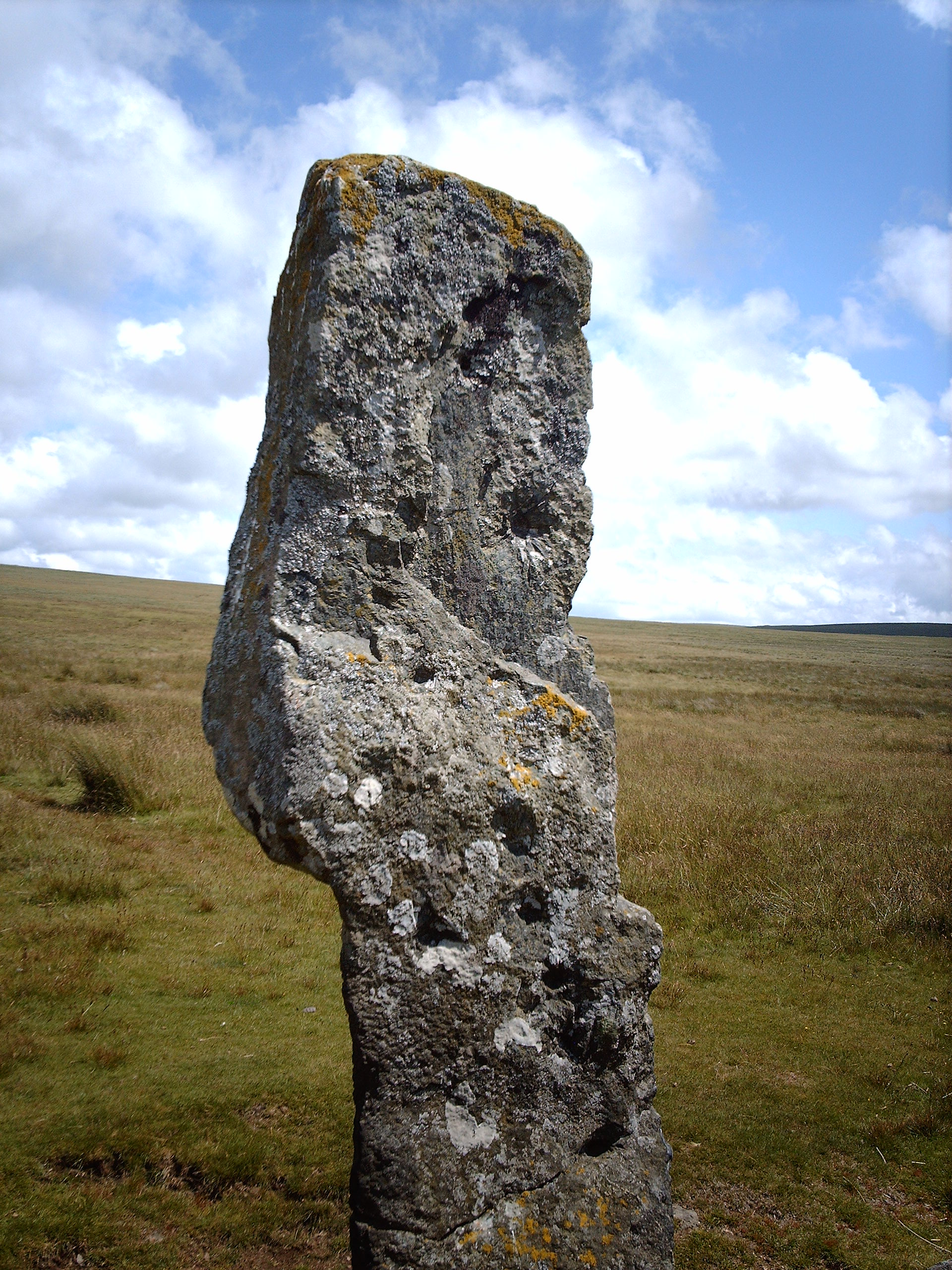
A little further on you come to Langstone, i.e. ‘long’ stone, Moor and the eponymous standing stone at the head of a row of low stones called a reave, an ancient stone wall, a particular feature of Dartmoor. Various illustrious commentators have put forward the theory that reaves, or indeed any linear feature on Dartmoor, are boundaries. The idea that anybody, ancient or modern, would spend a lot of money demarcating this unproductive land rather than spending a small amount of money demarcating the animals is obviously wrong and may give rise to a misleading portrayal of prehistoric Dartmoor as some kind of pastoral Eden. The menhir is a very welcome sight in the middle of a desolate expanse of moorland and it is not hard to imagine travellers in the past feeling similarly reassured. Of course we have no real idea of how many menhirs were on Dartmoor when the system flourished—this one was only re-erected in 1893 by the Dartmoor Exploration Committee. It has a slightly twisted shape, reminiscent of a lightning symbol, though again we cannot tell whether menhirs in general were shaped other than utilitarianly. Fancifully its forked shape marks the fork in the road here where a track coming from the main road to the south joins the Lich Way, one of Dartmoor’s ancient long distance tracks. Lich Way is a variation of lyke way, Llech means stone so take no notice of theories about ‘coffin roads’. This latter theory has taken root presumably because carrying coffins up and down across the bleak midwinter moorland has an inescapable filmic appeal; however the notion that people would actually go to all the trouble of building paths and roads just so they can carry a coffin along it once in a while is just plain weird. How these modern legends get Chinese-whispered around the academic community is a wonder of the age. Lich Way is far more likely to mean what its name says, a paved track.

Langstone Moor menhir
The stones at the base are the north-easternmost remains of a reave, a low stone wall. They are routinely described as boundaries but devoting valuable resources to demarcating boundaries in such poor terrain is highly unlikely. Marking sheep was a more practical method and, as you cannot fail to notice all about you, is still used today. Some reaves stretched for miles across the moor in parallel SW-NE lines and are thought to have been established in the Neolithic.
Before continuing across Langstone Moor, make a detour to White Tor, less than half a mile away to the north-west. Like many tors, you will find it crowned by a pile of conspicuous granite boulders. This is a good moment to consider what Dartmoor tors really are. For instance, do those boulders look naturally strewn about? You would probably say ‘Yes’ without further thought but further thought might prompt you to wonder why boulders are not ‘strewn about’ everywhere on Dartmoor. After all, unlike arable areas, it is very unlikely that Dartmoor has been systematically cleared of rocks. But suppose these boulders had been systematically placed where you see them? What effect would that have had over the several thousand years when the rest of this wet-and-windy landscape, not protected by boulders, has been subject to all the forces of erosion? They would loom higher and higher out of the surrounding countryside. Of course the same thing would happen even if the boulders had been naturally aggregated and in any case we cannot assume, even if Megalithic Man did deliberately arrange the boulders, his intention was to create a tor. All one can say is that the tors tend to be individually named and always act as landmarks. Anyway, something to ponder as you pick your way among blocks of granite trying to decide if they are cairns, enclosure walls or random heaps.
White Tor used to be described as an Iron Age hillfort, but this has recently been amended to ‘Neolithic enclosure’[3]. Actually it closely resembles a pound on Bodmin Moor near the Cheesewring which is connected to mining so the jumble of stones here is most likely spoil left behind by mining operations though White Tor is situated close enough to a meeting point of tracks to have been a convenient location for a spot of bartering.[4] After retracing your steps from White Tor to the Langstone Menhir, follow the path south-east for about half a mile, skirting a bog, until you reach a stone circle in the middle of Langstone Moor. The stones were restored in 1894 by the good people of the Dartmoor committee but knocked down again by soldiers in the US army practising for D-Day (which makes them good too). The Lich Way is about a mile to the north of the menhir but the track is sunken and overgrown and not easy to pick out.
Five minutes’ walk south-west of the circle (there is no obvious path) brings you to a large settlement or ‘pound’ consisting of a series of hut circles within an outer stone wall, in better condition than any of the hut circles so far. The entrances to the huts are marked by stone doorposts and face south away from the centre. The nearby quarry and lack of alternatives would indicate this to be an old pit village. You will see to your south that the area above Merrivale is littered with the detritus of tin-mining and the ‘pound’ is at the head of a stream, the Grimstone Leat, which flows down to the quarry.
The best way back is to go south via the Walkham valley for a couple of miles, walking on well-grazed grass near the leat that winds gently along the bottom of the valley. By keeping to the leat you will be brought safely down onto the Tavistock-Princetown road even if visibility is too poor to make out the rock outcroppings on top of Staples Tors to the right. A couple of bridges cross the leat so you can walk on either side. Boulders obstructing the track further down on the right-hand bank were probably deposited by tinners ‘streaming’, washing ore from surface gravel.
After about a mile you come to a drystone wall enclosing a couple of fields and following it round will take you the rest of the way back to Merrivale quarry and the cinder path that joins the road a few minutes’ walk from the Dartmoor Inn. The pub has unsociable opening hours and may well be closed even at weekends. You should not, however, be thirsty since the water in the streams, even from bogs, has been tested and shown to be pure enough to drink The car park is to the east less than a mile away from the inn.
You will probably end up feeling that you have visited an abandoned industrial site; the ‘ruggedness’ of Dartmoor may be the result of old slag heaps and other leftovers of mining activity, now so weathered as to appear natural. There is even the possibility that all ‘moors’, ‘heaths’, ‘bogs’ and wastelands in general are essentially human artefacts. Tinning was presumably carried out on a grand scale, not just on Dartmoor or even Devon; the rest of the country, in particular the west coast, may one day be reassessed as a potential industrial/ mining landscape.
Industrial spoil is only one possible route; there is also over-grazing, over-cropping, de-forestation and the construction of deliberate hunting preserves. The point here is that pre-historians should not passively take geographers’ assurances about essential geographical causation, such as underlying soil types, altitude, climate and so forth, as gospel. Britain has been intensively interfered with for ten thousand years!
[1] A school was built here in the early twentieth century for the children of quarrymen working in Foggintor Quarry over a mile away from Merrivale, a typical example of how a site that was levelled in antiquity and next to a road gets re-used in modern times even if it is not always the most suitable location.
[2] Granite from the nearby Foggintor Quarry has been used to construct monuments of national importance such as Nelson’s Column and London Bridge. Merrivale Quarry was the last working quarry on Dartmoor.
[3] The term ‘tor enclosure’ was coined in the 1970’s when archaeologists were having difficulty assigning defensive purposes to such sites. What are taken to be weapons can also be mining implements. It is just the same today on Dartmoor where explosives may be employed by the army or quarrymen.
[4] There is an etymological link between markers at forks and cross-roads and the markets that were established around them as in ‘marcher’ words in various European languages. The Ancient Egyptian merkhet was a surveying tool similar in function to an astrolabe.
Leave a Reply